Vegetation Management
Surry-Yadkin EMC has implemented a Vegetation Management Program that reflects a balanced approach to addressing environmental concerns, and increasing operating costs. The cooperative also considers the impact on wildlife habitat, aesthetics, public and employee safety, outage mitigation, and system integrity and reliability. Surry-Yadkin EMC maintains over 4,000 miles of distribution lines and just over 105 miles of transmission lines in our five-county service area that encompasses Surry, Yadkin, Wilkes, Stokes and Forsyth Counties.
The main focus of Surry-Yadkin EMC is to provide outstanding electrical service to our more than 27,000 members at affordable rates. Surry-Yadkin Electric’s goal is to deliver safe, reliable and affordable electrical service to our homes, churches and business. Clearing trees, limbs, and brush allows Surry-Yadkin EMC to not only deliver outstanding service, but it also allows us to prevent outages, blinking lights, safety hazards, and ultimately helps employees restore service more quickly during storms.
Our Vegetation Management Program uses various mechanical methods for clearing, side trimming, pruning and mowing existing rights-of-way and for clearing new rights-of-way.
Mechanical methods of maintaining right-of-way is one important part of our Vegetation Management Program. However, even with proper mechanical methods our job is not over. Once mechanical crews have cleared the vegetation along the right-of-way corridor, a mature root system is left intact. This root system will produce sprouts that will be 12’ to 20’ tall before we return, which can lead to power outages, blinking lights and hazardous conditions.
To help address this problem, we will begin using herbicides this spring to reduce low-level vegetation along our rights-of-way through a low-volume herbicide application. Once the right-of-way has been mown, it is allowed to grow for 1 year and achieve a height of 2’ to 6’. Contract applicators licensed by the State of North Carolina will walk through the right-of-way wearing backpack containers, and use handheld wands to apply herbicides at very low rates to brush, saplings, vines and other woody stemmed species to control only these specific types of vegetation. Grasses, wildflowers, and shrubs will be left untouched. The following year contract applicators will inspect that corridor to ensure that everything was properly sprayed. If not they will re-apply herbicides to that specific vegetation. What we will all see happen is that the brush, saplings, vines, and other woody stemmed species have not re-established themselves and that the grasses, wildflowers and shrubs are thriving. What this leads to is a better right-of-way that is safer for our employees to work in, and more efficient to manage. Once the initial application has been made we will return in 3 years to retreat the right-of way-corridor. What we will see is a conversion from a woody, brush filled corridor to a green-way corridor filled with native grasses, flowers and shrubs.
Introducing low-volume herbicide application into our Vegetation Management Program was not a decision that we made quickly, or took lightly; we arrived at this decision after years of careful consideration and research. What we discovered is that the introduction of low-volume herbicide application will bring many benefits to not only Surry-Yadkin EMC as an electric cooperative, but also to its members, communities, and wildlife habitat.
For right-of-way trimming and service drops, there are minimum clearance standards we follow, as well as a variety of pruning methods.
Minimum Clearance Standards are as follows:
- Lateral Clearance for all trees will be 12 feet or 4 years of growth, whichever is greater.
- Vertical Clearance for all trees located directly beneath primary conductors will be 10 feet or 4 years of growth, whichever is greater.
- 20 feet of clearance or the reach of mechanical equipment whichever is greater for all branches that overhangs the conductors on single-phase line sections.
- No overhanging branches on multi-phase lines.
- All secondary conductors that are in contact with vegetation shall be pruned around during scheduled clearing.
Pruning Methods are as follows:
- Crown reduction – reduces a tree’s height and spread by selectively cutting branches back to smaller, upward-growing lateral branches to preserve the tree’s natural shape and health.
- Side pruning – involves trimming branches on one side of a tree to guide growth away from obstacles.
- Overhang pruning – involves safely trimming branches that extend over desired boundaries such as a property lines or utility lines.
- Under pruning – removes lower branches to lift the canopy for clearance.
- Directional pruning – removes branches to guide future growth away from obstructions by cutting back to a truck or strong, outward-growing limb rather than leaving studs.
- Round-overs as long as clearance standards are achieved. Round-overs, also called topping, removes large branches to stubs creating a rounded shape for size control or utility line clearance.
- Reduced operating costs: Low-volume herbicide application helps the cooperative save time and money by using selective herbicides at low rates to control the brush, saplings, and vines. This process also allows us to quickly access overhead lines, poles and other facilities, and reduces the frequency that vegetation management work needs to be performed on the right-of-way.
- Reduces Service Interruptions: Vegetation is the leading cause of power outages and blinking lights. Using herbicides together with proper mechanical pruning methods will help reduce the number, duration and frequency of outages and blinking lights.
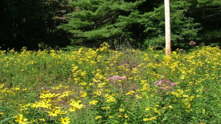
- Enhanced Property Appearance: Using selective herbicides at low-application rates will control invasive and undesirable vegetation, and leave the desired vegetation like grasses, wildflowers, shrubs and other native species untouched. Herbicides allow the vegetation to continue to grow, which will enhance the beauty of the property.
- Increases Vital Wildlife Habitat: When the right-of-way corridor is mown, it removes all vegetation down to the ground and also removes wildlife habitat. Low-volume herbicide application on the other hand targets only the brush, saplings, vines and other invasive woody stemmed vegetation and leaves intact grasses, wildflowers, shrubs and other native species that is vital to our native wildlife and pollinators. The use of low-volume herbicide application is endorsed by many wildlife advocacy groups, such as the National Wild Turkey Federation.
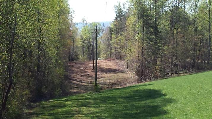
Pictured above is a right-of-way on our system in Surry County. The vegetation ranges from 14’ to 20’ tall. The pole and overhead lines are inaccessible. Surprisingly this right-of-way had been mown about 3 year prior to this photo.
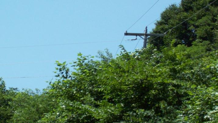
Pictured above is a right of way that is actively treated with low volume herbicide application. Notice that the over grown vegetation is not there and that the grasses, wildflowers and other desirable vegetation are thriving and access to the pole is unrestricted. (This photo is courtesy of our sister cooperative French Broad EMC in Marshall.)
We will be using 3 specific herbicides along with a sticking agent, surfactant and coloring agent.
Herbicides Used:
The herbicides listed above are applied to the leaves of the plants, and then they travel to the plants’ root system and control the plant permanently. These herbicides have similar plant-specific modes of action to control vegetation. Dow AgroSciences Rodeo and Nufarm Polaris both affect the plants’ ability to process amino acids, while Dow AgroSciences Milestone VM disrupts the plants metabolic growing process. A surfactant is used to reduce the surface tension of water so that it will not pool on the plants leaves, and a sticking agent is used to help the water-based herbicides stick to the leaves of the plant. The coloring agent is required by the State of North Carolina to show DOT personnel where we have sprayed when our rights-of-way overlap.
We have contracted with Top Gun Application Services LLC to perform all of our low-volume herbicide application on a three-year cycle; they have over 20 years of experience and were highly recommended by other electric cooperatives and industry professionals. If you would like more information on our Vegetation Management Program please call or email Kenny Mosley, right-of-way and system inspections supervisor, at 336-356-5256.
Interesting links on herbicides:
CWC Chemical is the distributor of all herbicides used on Surry-Yadkin EMC’s system.
Aqumix is the company we used to custom blend and package all herbicides on Surry-Yadkin EMC’s system; all packaging is done in returnable and refillable containers.
Integrated Vegetation Management Fact Sheet from the U. S. Environmental Protection Agency
http://www.epa.gov/pesp/htmlpublications/ivm_fact_sheet.html
Current Herbicide schedule
Double Creek Substation (Stokes County)
* Distribution Line (feeder) 1 - N.C. 268, Osborne Joyce Rd, Bud Tilley Rd, Rock House Rd, King Rd, N.C. 66, Taylor Rd, Frye Rd, Dan George Rd, Moores Spring Rd, Hanging Rock Park Rd
* Distribution Line (feeder) 2 - Oscar Frye Rd, Flat Rock Rd, Old Mill Rd, Tillotson Rd
* Distribution Line (feeder) 3 - N.C. 268, Sechrist Loop, Venable Rd, Pilot Westfield Rd, Mitchell Rd, Carson Rd, McDaniel Rd
* Distribution Line (feeder) 6 - Brown Mountain Rd, McDaniel Rd, Johnson Farm Rd
* Distribution Line (feeder) 7 - Brown Mountain Rd, Jackson Rd, King Rd, Tom Smith Rd, Vineyard Rd, Simmons Rd
Pinnacle Substation (Surry County & Stokes County)
* Distribution Line (feeder) 1 - Pilot Church Rd, Corner Rd, Shoals Rd, Jim McKinney Rd, Pilot Power Dam Rd, N.C. 268, Bryant Mill Rd, Black Mountain Rd, Golf Course Rd
* Distribution Line (feeder) 2 - Quaker Church Rd, Pinnacle Hotel Rd, Ayers Rd, Stony Ridge Rd, West Old Phillips Rd, Roy Tuttle Rd, Bowen Rd, High Bridge Rd, Volunteer Rd
* Distribution Line (feeder) 3 - Quaker Church Rd, John Scott Rd, Shoals Rd, Caudle Rd, Hauser Rd, Grassy Creek Rd, Robert Owens Rd, John Mickles Rd, Butner Rd
* Distribution Line (feeder) 4 - Quaker Church Rd, Eldora Rd, Nurse Rd, Romie Brown Rd, Rock Hill Church Rd
Baltimore Substation (Yadkin County)
* Distribution Line (feeder) 1 - Baltimore Rd, Binkley Rd, Hobson Rd, Mount Bethel Church Rd, Indian Heaps Church Rd, Hennings Rd
* Distribution Line (feeder) 2 - Cornelius Rd, Bloomtown Rd, Scott Rd, Shallowford Rd
* Distribution Line (feeder) 3 - Bruce Rd, Speer Bridge Rd, Hollar Rd, Turners Creek Rd
* Distribution Line (feeder) 4 - Cornelius Rd, Bloomtown Rd, Frye Rd, Jones Rd, Dalton Rd, Scott Rd, Shallowford Rd, Hauser Rd, Dorse Rd, Westbend School Rd, Double Spring Rd, Williams Rd
East Bend Substation (Yadkin County & Forsyth County)
* Distribution Line (feeder) 6 - Butner Mill Rd, Hauser Rd, N.C. 67, River Bluff Farms Rd, Ridge Rd, Boiling Springs Rd, Rolling Hill Dr, Tobaccoville Rd
* Distribution Line (feeder) 7 - Butner Mill Rd, Aquila Creek Rd, Speas Ferry Rd, Taylor Rd
* Distribution Line (feeder) 8 - Araby Ln, Flint Hill Rd, Mount Bethel Church Rd
* Distribution Line (feeder) 9 - Macedonia Rd, Apperson Rd, Union Hill Rd, Old Mill Rd, Marler Rd, Shoals Rd, Shady Grove Church Rd, Smitherman Rd
Center Substation (Yadkin County)
* Distribution Line (feeder) 6 - Little Mountain Rd, Evans Rd, Vestal Rd, Simmons Patton Rd
* Distribution Line (feeder) 7 - Swains Church Rd, Shaw Rd, Whitaker Rd, Hemric Rd, Longtown Rd, Wilmoth Rd, Ralph Rd, Casstevens Rd, Ireland Rd, Petty Rd, Arnold Rd
* Distribution Line (feeder) 8 - Rena Rd, Pinnix Rd, Armstrong Rd, Bethel Rd, Bagley Springs Rd, North River Ridge Rd
Slate Mountain Substation (Surry County)
* Distribution Line (feeder) 6 - Norman Rd, Mount Herman Church Rd, Brim Rd, Bob Jessup Rd
* Distribution Line (feeder) 7 - Slate Mountain Rd, Woodville Rd, Albion Church Rd, Rogers Rd, Asbury Rd, Jessup Rd, Flippin Rd, Joyce Mill Rd, Joyce Acres Rd, Asbury Speedway Rd
* Distribution Line (feeder) 8 - Slate Mountain Rd, Athey Simmons Rd, Blue Hollow Rd, East Pine St (N.C. 103), McBride Rd
Lowgap Substation (Surry County)
* Distribution Line (feeder) 6 - Old Lowgap Rd, North Wilson Rd, Lumber Plant Rd, Round Peak Church Rd, Casper Stewart Rd, Tony Holder Rd
* Distribution Line (feeder) 7 - N.C. 89, Flippin Rd, Beulah Church Rd, Wandering Walk Rd, Palmer Rd, Round Peak Church Rd, Bryant Rd
* Distribution Line (feeder) 8 - N.C. 89, Ramey Creek Rd, Bartley Rd, Wildlife Club Rd, Carson Creek Rd, Boyd Dickens Rd
Transmission lines
* Lomax (Wilkes)
* Mining Ridge (Wilkes/Surry)
* Westfield (Surry/Stokes)
* Pipers Gap (Surry)
* Francisco (Stokes)
* North Elkin (Surry)
* Double Creek (Stokes)
Current Right-of-Way trimming schedule
Ted Holyfield (Salem Fork) Substation (Surry County)
* Distribution Line (feeder) 6 - White Dirt Rd, Money Rd, Hodges Mill Rd, Tobe Hudson Rd, Casstevens Rd
* Distribution Line (feeder) 7 - Zephyr Rd, Tobe Hudson Rd, Gillespie St, Old Hwy. 601, Phillip Branch Rd
* Distribution Line (feeder) 8 - Zephyr Rd, Kapps Mill Rd, Bert Cockerham Rd, Crossroads Church Rd, Judsville School Rd, Red Hill Creek Rd, Haystack Rd, River Rd, Reynolds Rd, Devotion Estate Way
* Distribution Line (feeder) 9 - Twin Oaks Rd/ Zephyr Rd intersection
Lowgap Substation (Surry County)
* Distribution Line (feeder) 6 - Old Lowgap Rd, North Wilson Rd, Lumber Plant Rd, Round Peak Church Rd, Casper Steward Rd, Tony Holder Rd
* Distribution Line (feeder) 7 - N.C. 89, Flippin Rd, Beulah Church Rd, Wandering Walk Rd, Palmer Rd, Round Peak Church Rd, Bryant Rd
* Distribution Line (feeder) 8 - N.C. 89, Ramey Creek Rd, Bartley Rd, Wildlife Club Rd, Carson Creek Rd, Boyd Dickens Rd
Pipers Gap Substation (Surry County)
* Distribution Line (feeder) 6 - Arless McCraw Ln, Pipers Gap Rd, Miller Rd, Silver Tab Trail, White Pines Country Club Rd
* Distribution Line (feeder) 7 - Sparger Rd, Plowboy Trail, Laila Ln
* Distribution Line (feeder) 8 - Pipers Gap Rd, Imogene Church Rd, Sparger Rd, Goins Rd, Beamer Rd
Yadkin Substation (Yadkin County)
* Distribution Line (feeder) 1 - Pendry Rd, Richmond Hill Church Rd, Lime Rock Rd, Crissman Rd, Shady Grove Church Rd
* Distribution Line (feeder) 2 - N.C. 67, Genie Rd, Mill Hill Rd, Dal Rd, Indian Heaps Rd
* Distribution Line (feeder) 3 - Rockford Rd, Union Grove Church Rd, Sizemore Rd, Union Cross Church Rd, Lace Knoll Rd, Styers Mill Rd
* Distribution Line (feeder) 4 - McKnight Rd, Speer Rd, Moxley Rd, Reece Rd
* Distribution Line (feeder) 5 - Rockford Rd, Round Hill Rd, Sugartown Rd, Tennessee St, Fairway Dr, Hinshaw Rd
Mining Ridge Substation (Wilkes County)
* Distribution Line (feeder) 6 - Mining School Rd, Dry Wall Rd, Golden Rd, Oscar Calloway Rd, Possum Trot Rd, H.G. Lewis Rd, Union Hill Rd
* Distribution Line (feeder) 7 - Mining Ridge Church Rd, Murray Rd, Couch's Fish Lake Rd, Cool Springs Church Rd
* Distribution Line (feeder) 8 - South Center Church Rd, South Fork Ln, Haystack Rd, Union Hill Rd, Royall Rd
* Distribution Line (feeder) 9 - South Center Church Rd, Roaring Gap Rd, Wiley Royal Rd, Traphill Union Rd, Traphill Rd
Mount Airy Substation (Surry County)
* Distribution Line (feeder) 1 - Long Hill Rd, Simmons Grove Church Rd, Cook School Rd
* Distribution Line (feeder) 2 - Long Hill Rd, Simmons Grove Church Rd, Simmons Rd, Community Building Rd, Toms Creek Rd, Dodson Mill Rd, N.C. 268
Fairview Substation (Surry County)
* Distribution Line (feeder) 1 - Rockford Rd, John Davis Rd, U.S. 601, Cave Rd, Brindle Rd, Caves Mill Rd, East Atkins St
* Distribution Line (feeder) 7 - Rockford Rd, Hamlin Ford Rd, Turkey Ford Rd, Turner Mountain Rd
Transmission lines
* Slate Mountain (Surry)
* Francisco (Stokes)